Friday, November 26, 2010

Glacier National Park, The Great Northern Railway and the Blackfeet Portraits of Winold Reiss.

In this year of 2010, Glacier National Park is celebrating 100 years as a national treasure. The Park, which straddles the Montana Canadian border in Northwest Montana, is one of the most remote of all parks in the National Park system. If it was not for the effort of railroad giant, James Hill, who pushed legislation through the U.S. Congress establishing Glacier 1910, this scenic wonderland of the Northwest may not have been preserved for future generations.


Glacier National Park

James Hill envisioned a “Playground of the Northwest” that would attract people and their money from all over the world, moneyed people who traditionally traveled and enjoyed the sights and attractions of Europe. To interest visitors to Glacier, Hill, with the help of his son, Louis, embarked on an ambitious building spree, where they built a chain of hotels, chalets, boats, roads, and trails in the mountains of Glacier and created the banner, “See America First,” in order to entice visitors to the Rocky Mountain Northwest.


Many Glacier Hotel

The motive behind all this activity was to promote travel on Hill’s Great Northern Railway.


James Hill was one of several “captains” of the railroad industry in the United States, who made a fortune from investment in the transportation of goods and people on railways that linked America from coast to coast after the Civil War. In 1893, Hill’s Great Northern Railway connected the Upper Mississippi River Valley to Puget Sound.

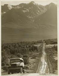
Great Northern Route

All along the route from Minneapolis to the Pacific, Hill promoted the Northwest as a wonderland of natural beauty; a land that still possessed many of the desirable attributes inherent in the American frontier. Hill also cashed in on the growing popularity of what historians in the twentieth century describe as the mythic West; a perception of the West in the American mind, where the exploits of cowboys, frontier army and Indians denoted adventure and unbridled heroism. The Native Americans, in particular, were of interest because of their role in promoting the “Wild West” with their performances in Buffalo Bill Cody’s wild west shows, which toured the United States and Europe between 1883 and 1917. At every stop along the tour, Native Americans in the show helped to recreate the Indian wars of the plains, audiences loved the excitement of western America. In the early twentieth century, The Great Northern helped to keep this romantic image of Native Americans alive by promoting the Blackfeet Nation, whose reservation extended along the eastern boundaries of the park; a trip to Glacier brought visitors in close proximity to the Blackfeet and their culture.


Blackfeet Indian Reservation

Traditionally the Blackfeet nation consists of three different tribes with the same language and customs; the Pecunnies (Piegans), the Bloods, and the Blackfeet. Before moving onto the Plains, and adapting a nomadic culture centered on the buffalo, the Blackfeet lived around the "forest near Lesser Slave Lake. Incessant war forced upon them by the powerful Chippewas pushed them steadily southward until they reached the wide plains bordering the Rocky mountains in what is now Montana."[Frank Bird Linderman] The Blackfeet eventually occupied a region that ran north to south from Saskatchewan to the Yellowstone. Early Plains settlers and frontier military viewed the Blackfeet as a warrior society, who resisted white settlement in their region. At the end of the Plains Indian wars in the 1870s, the federal government moved the Blackfeet to land reserved for them east of what became Glacier National Park.


Blackfeet 1914

Once on reservations, the Blackfeet, along with other Native America Tribes, occupied the interest of anthropologist, writers and artists; many flocked to the American West in order to record what they believed were the last vestiges of Native America life. James Hill understood the draw that the Blackfeet would have as a “tourists attraction,” the search was on for an artists, who had a close association with the Blackfeet, and who could capture in Blackfeet portraits the colorful character of the people. The Great Northern Railway found such an artist in Winold Reiss.

The Blackfeet gave Winold Reiss the name Beaver Child when they inducted him into the tribe in the winter of 1919.


Winold Reiss

Reiss was born in Karlsruhe, Germany, the Black Forest region. He gained appreciation for cultural differences among people from his father, a German artist who focused his art in peasant cultures of the Black Forest. Both father and son trained at the Royal Academy in Munich. Winold was fascinated with the Indians of North American, a fascination fueled by the novels of James Fenimore Cooper. In 1913, Winold Reiss traveled to American to study the North American Indians. Reiss believed that he could use his art to break down racial barriers by picturing the honor, beauty, and dignity of all peoples. His bold style, coupled with his attention to detail of racial characteristics and cultural customs, made his Blackfeet portraits unique. In the summer of 1943, Reiss once again stayed with the Blackfeet, finishing 75 portraits. Many of these portraits appeared on Great Northern Railway calendars


and were included in a portfolio sold by the Great Northern Railway to promote Glacier National Park and rail travel to Blackfeet country in the 1940s.

Portraits of the Blackfeet people by Winold Reiss:


Jim Blood, an old Pecunnie brave


Only Child, Pecunnie girl sitting against a tepee back-rest made of thin willow sticks


Plume, a modern representation of the Kainahs--proud owner of many lodges, horses and a large heard of cattle.


Short Man, A fine old warrior of the Pecunnies who lived until his eight-sixth year. He was an expert sign talker.


Big Face Chief, A stalwart member of the north Pecunnie band of Blackfeet. His necklace and eagle wing fan mark him as a Medicine Man.)

Wednesday, November 17, 2010

The Alaska-Canadian Highway


In 1942, the Army Corp of Engineers built the Alaska-Canadian Highway(service men called it the AlCan Highway) from Dawson Creek in the Yukon to Delta Junction, southeast of Fairbanks, Alaska. Initially, the rough gravel road was thought necessary for American national security during the Second World War.


Today, tourist travel the AlCan highway as a more adventurous route to Alaska than traveling by boat along the North American costal waterway.


Inside Passage

A highway to link the lower 48 states to Alaska Territory was first proposed in the 1920s by Donald MacDonald, a senior engineer with the Alaska Road Commission. MacDonald believed that a coastal route from Prince George in British Columbia to Alaska’s southeastern towns would benefit commerce and would be an easy route to forge over already familiar territory. The biggest problem in the 1920s for construction of the highway was convincing the Canadian government that a road through Canada was necessary; The Canadians were reluctant to provide funds reasoning that there were few Canadians living in the area proposed for the highway.

The attack on Pearl Harbor in 1941 and the fear of Japanese invasion of the North American coast and the Aleutian Islands brought the proposed highway back to the front burner. The United States Army believed that “a secure overland supply line to the unfinished airfields of the Northwest Staging Route and our military bases in Alaska was urgently needed.” The Army approved the project in 1942 and authorization from the U.S. Congress and President Franklin D. Roosevelt followed within days. Roosevelt understood that for homeland security there needed to be a supply line to airfields and military bases in Alaska. Roosevelt’s proposal was not without objections from those who considered many of the President’s programs “boon-doggles.” Roosevelt’s administration justified the billion dollar projected thusly: “That the effective defense of Alaska is of paramount importance to the defense of the continent from the west since Alaska is most exposed to an attempt by the enemy to establish a foothold in North American….That sea communications with Alaska in the future may be subject to serious interruption by enemy sea or air action. That the air route to Alaska and the defense facilities in Alaska cannot be fully utilized without adequate means of supply, for the air route, this can be best provided by a highway along this route.”

The need was apparent, the route was still contested. In all there were four routes considered; route A along the coast; route B following the Rocky Mountain Trench; route C inland; and route D, which followed the Mackenzie River System. Of all routes, the route C was the most difficult to cut and critics believed it would take the longest to forge through uncharted wilderness. But, the Army liked route C because it was a direct line to the newly constructed air bases.

The United States brokered a deal with Canada that allowed a highway through Canadian wilderness.


AlCan Highway 1942


Even though the Canadian Government had no objections to the route through Canada, they would not grant funds for the highway, and insisted that after the war the road would be turned over to Canada. The Army Corps of Engineers started work on the highway in late spring of 1942. It was not an easy engineering feat for the Army to construct a highway through 1522 miles of rugged unmapped wilderness.


Some compared the construction of the highway with the building of the Panama Canal and Hoover Dam. It was especially difficult to build the road considering that Army manpower for such projects was scarce. But, there was an untapped pool of men in the army’s black Corps of Engineers; The Army sent the 93rd, 95th , 97th and 388th units, trained in Alabama, Florida and Georgia, to help construct the highway. Of the 10,670 men, military and civilian who worked on the highway, 3, 695 of Army Troops were African-American.


At the beginning of armed conflict in Europe and the Pacific, African Americans in the U.S. Military were not allowed to serve on active duty. But, after the Japanese bombed Pearl Harbor, a lack of manpower in the army started to change the prevailing view of African American’s role in the United States armed forces. But, perhaps the attack by the Japanese at Midway Island, and the attack at Dutch Harbor in June 1942 in Alaska’s Aleutians Islands (the only battle in the Pacific War that was fought in North America ) brought home the necessity for all Americans to work along side one another for a common goal to defeat the enemy.

It took 8 months to build the Alaska-Canadian Highway. Construction began in the late Spring of 1942. The work was difficult if for no other reason than the wilderness terrain and the adverse weather condition. Memories of African-Americans mentioned the harsh living conditions in the very cold winter. They had to fight against frostbite and hoped to survive wading chest deep in freezing cold lakes to build bridges.


95th

During the winter months, the temperature dropped to -70 degrees. One veteran remembered. “ For months on end, I couldn’t get a real night’s sleep. I had nightmares I was freezing to death.”


"We wore three pairs of socks at times, with rubber galoshes instead of shoes, because the leather would freeze. We had adequate clothing-- lined parkas, pants, mittens and heavy underwear, but it was still might cold. But I was a young man who felt he had a job to do, and I did it."
-Alexander Powel, Crane Operator, 97th Engineers


The troops lived in temporary tent camps in an environment where temps could easily go to 40 below zero. Their mess facilities were out of doors and food was served up in mess kits that some suggested were “slightly improved from the Civil War.”


Their tents were equipped with wood stoves, wood they cut by hand with cross cut saws and double-bitted axes. These same axes were used to clear the highway path while bulldozers pushed stumps out of the way. Timber that they cleared was also used to make bridges and culverts.

The Alaska Canadian Highway took eight months to complete. Proponents of the highways believed it was the single most engineering feat of World War Two. The highway was immediately used as the intended supply line to air bases in Nome and Fairbanks. In all, 7000 planes were delivered to Alaska. All along the route, every 300 miles, the service men built gravel run ways for planes to refuel and continue their trek to Russia and the European Allies.

Building of the AlCan highway was more than an engineering feat; it brought together black and white soldiers who worked outside segregation for a common goal of duty and the protection of the United States of America.

The Army completed the AlCan Highway on November 20, 1942. Construction crews worked from both ends of the Highway and met at what is now called "Soldier's Summit" at Kluane Lake in Yukon Territory.


Kluane Lake
Henry George Glyde
Canadian (1906-1998)
Kluane Lake on Alaska Highway, 1949
oil on canvas
Glenbow Museum Collection

In 1948, the Alaska-Canadian Highway was opened to the public. The rough gravel road was paved in the 1990s


Today’s Highway