Wednesday, July 13, 2011

Ancestral Puebloan People of MesaVerde

On a cold wintry December day in 1888, Richard Wetherill and his brother-in-law, Charlie Mason, cowboys from the Alamo ranch in Southwestern Colorado, spent most of their afternoon rounding up strays on the high mesas and steep canyons above their winter camp on the Mancos River. The going was tough and blowing snow made hard work of finding their cattle. As they rested their horses on the edge of a mesa, they saw at the far side of the canyon a complex of stone buildings built under a large outcropping of rock. Under this protective rock overhang was a village of houses, towers, and kivas, all strung together like a huge apartment complex. The cowboys named the location Cliff Palace. Years later, Charlie Mason described their discovery, “From the rim of the canon we had our first view of Cliff Palace…. To me this is the grandest view of all among the ancient ruins of the Southwest. We rode around the head of the canon and found a way down over the cliffs to the level of the building. We spent several hours going from room to room and picked up several articles of interest, among them a stone axe with the handle still on it.”


Cliff Palace as seen by Richard Wetherill and Charlie Mason in 1888.


Debris field around structures.


Cliff Palace 2011

Diagram of structures at Cliff Palace


No one knows for sure who constructed, with such skill, a community of buildings high up on the side of a canyon wall; buildings that have survived the harsh elements of the mesa country for over a 1000 years. Anthropologists and historians refer to the people as hunters gathers, basket makers, cliff dwellers, Anasazi, (Navajo for “ancient ones) or more formally, or Ancestral Puebloan People. All that is known about them is found in the ruins of their cliff dwellings. (The Anasazi occupied a large area of mesa and canyon lands known today as the four corners, where Colorado, Utah, Arizona and New Mexico meet.)

After the Cowboys discovered Cliff Palace, they used their winter camp in the Mancos Valley as a base from which to explore the canyon close to their initial discovery (later to be called Cliff Canyon).

The mesa above Cliff Canyon. From this vantage point, the cowboys looked across to the ancient ruins.

Over the next two months, Wetherill, Mason and cowboys from the Alamo ranch dug through the ruins collecting artifacts, some of which they sold to a museum in Denver for $3000.00. (The artifacts helped launch the newly established Denver Historical Society museum) Other artifacts were kept in a barn on the Alamo ranch.

Below are some of the artifacts found by the cowboys from the Alamo Ranch.


Baskets made from the fiber of the yucca plant. The Yucca plant served many purposes in the Ancestral Puebloan culture.

Clay bowls with a distinctive design.

Regardless of the monetary value of the artifacts in the ruins, the Wetherills, owners of the Alamo Ranch, understood the archaeological and historical value the ruins had to Colorado and to the nation. Richard Wetherill wrote to the directors of the Smithsonian and Harvard’s Peabody Museum requesting that these institutions sponsor him and his brothers or at least send their own specialists to work with them to excavate the cliff dwellings. Neither museum offered financial assistance or a team of professionals to help in excavating the ruins. Without outside help, the ruins would continue their march into obscurity; the Wetherills could not take the time away from ranching to explore further the ruins of Cliff Canyon. Not until Gustaf Nordenskiold from Sweden, an adventurer of sorts, heard about the cliff dwellings in the American Southwest, did Cliff Canyon and the Anasazi people get attention from the scientific community. In 1891, Nordenskiold made the long journey to America, crossed the continent on the newly established Santa Fe line to Durango, and forty miles by buggy to the Alamo ranch to meet with the Wetherill family. The family introduced Nordenskiold to the Cliff Dwellings, all of which were which named by the Wetherill family. The most impressive of the dwelling complex being Cliff Palace, Spruce Tree House, Square Tower House, Mug House and Sandal House. In all, the Wetherills counted 182 cliff dwellings. Today, the count is 600. After spending several years exploring the cliff dwellings and its artifacts, Nordenskiold wrote The Cliff Dwellers of the Mesa Verde, where he detailed each dwelling and the artifacts found at the different locations.
Spruce Tree House

Inside ruin of Spruce Tree House as discovered by the Witherills and Gustaf Nordenskiold

Spruce tree house 2011

Spruce Tree House 2011

Typically, in each of the complexes, small rooms were built around a kiva; some rooms had access to the kiva by tunnels. They also constructed a small opening adjunct to the kiva called a sipapu, which symbolized the entrance to the underworld or mother earth. In most kivas there are stone benches, and an area that appears to be a fire pit. There are different theories on the use of the kiva. The most popular thought is that the round recessed circular room was used for religious purposes, and most likely as a place for social gatherings. At Cliff House complex, there are 23 kivas.
There are also areas in the dwelling complex, where grain was ground in order to make flour that they used for multiple food preparations.

Also found on the mesa above Cliff Canyon were the ruins of villages, perhaps occupied by the ancestors of those who built the cliff dwellings. Archaeologists believe that the first people to occupy Mesa Verde did so around 2000 years ago. Anthropologists call these early people the basket weavers. These people lived in caves, but eventually by 750 A.D. moved into pithouses, a below ground system of housing around a kiva. The mesa environment was ideal for farming and there was enough moisture at the higher elevation of 8000 ft. to sustain agriculture. The Basket weavers mastered farming to where they had an expanded food supply and an increase in population. The people also began making crude pottery and developed the technique of crafting bows and arrows. By 1000 A.D. the basket weavers moved out of the below ground pithouses to above ground constructions made of pole and adobe. In this era, anthropologists refer to the above ground builders as the Anasazi, who improved building techniques by taking advantage of the natural environment that had an abundance of sandstone rock, which was easily cut into stone to build houses. The Anasazi became skilled masons, crafting each stone to an equal size to construct walls of their structures. They experimented with natural resources to develop mortar made out of sand, small gravel and ash. (This strong mortar can be seen in the ruins of Mesa Verde today.)

Far View Site, above ground village ruins at Far View site, Mesa Verde National Park

Far View Site.

The Kiva was important in the construction of the below ground pithouse. When they move to above ground living, the kiva became the only below ground element of their culture that transferred to Ancestral Puebloan culture.

Kiva

Drying racks line the walls of the kiva at the Far View Site, which indicates multiple uses of this kiva.

Agriculture land was on the top of the mesas. Archeologists are still trying to determine the canal system that ran from the reservoir in the picture below to the farming fields.

The National Park Service designation this reservoir, along with four others in Mesa Verde as a National Historic Civil Engineering Landmark. The water management system developed by the Anasazi people is one of the oldest engineered public works in the United States.

The Anasazi people grew three staple crops--corn, beans and squash all in the same field. The tall corn became a pole or sorts for the beans and the shade from the tall corn stalks protected the squash. They over produced, storing grain for the years of drought when rain or snow was not plentiful enough to sustain a crop.

The golden age of the Anasazi was between 1100-1300 AD. During this period they constructed houses with larger rooms, more complex attached buildings that could accommodate 1000 people. Their villages were spread out over many miles stretching across the mesas. During this era, the Anasazi demonstrated improved craftsmanship in masonry, pottery, weaving and jewelry. The evidence seems to indicate that all was well with the people who thrived on the mesa tops, but then they abandoned their above ground life to return to the caves and started engineering buildings along the cliffs. They used the same techniques that they mastered on the mesa tops; stone masonry buildings that fit under the rock umbrella perturbing out from the canyon walls.

Archaeologists and historians do not know why the Anasazi people left their prosperous villages and sought shelter along the canyon walls. One plausible explanation is that the canyons offered a defensible and secure location. Climate may also have been a reason for the move. Winter could be harsh on the mesa tops; the cliff dwellings offered a warmer environment.


Note the black soot on the back wall of the canyon. They constructed most of the structures with at least 3 to 4 ft. clearance from the wall. Evidence shows that they built their fires behind these structures. With small openings at the back of their rooms, the heat from the fires would penetrate their living quarters giving them a warmer environment.

The cliff dwellers still farmed on the mesas above and near some of their dwelling under the rock outcropping. At Spruce House complex, there is also a spring at the bottom of the canyon, which offered a water supply.

The inhabitants of the cliff dwellings only stayed under the protective rock for a couple of generations. By 1300, they were gone from the mesa. It is not known where the people migrated to, but most recent scholarship indicates that they are the ancestors of the Pueblo people. The most logical reason for their migration south would be climate change. A drought settled over the mesa region from 1272 to 1299, a long time to go with out a reliable food source. Also, years of farming on the mesa would have depleted the soil of nutrients to successfully grow crops and deforesting the land would cause erosion; the people had to move on to new fresh land where there was ample moisture to sustain life and agriculture. It is most probable that the hunter gathers, the Basket weavers, the Cliff Dwellers and the Anasazi people are the ancestors of the Pueblo people, who today live in the American Southwest.

Saturday, March 19, 2011

Detroit and the Mythical West.

It is not by accident that a family such as mine, born and raised in Detroit, Michigan, found a home in the America West. My dad grew up reading authors of the American West in the early twentieth century like Zane Grey and Louis L’Amour. When I was a child in the 1950s and 60s, family time was around the T.V. watching The Lone Ranger, Sky King, Roy Rogers, Maverick, Have Gun Will Travel, Wagon Train, Gunsmoke, Bonanza, etc.

The American West, and the characters, whether fictional or non-fictional, who sought adventure and “tamed” the western wilderness, represented to my dad, my family and a great number of fans around the world a sense of adventure, and a belief that good guys win in the end; an important concept in the era of World War Two and the Cold War.

Today the western genre is on life supports. In the troubled times of the 1960s, historians concerned with civil rights, Vietnam, and other social and political issues began to revise how historians of the previous generation interpreted American history, especially the role of Women, Native Americans, African Americans and Hispanics. The West I grew up on was now called the "Mythic West.” The new histories took our western heroes, as portrayed by numerous western writers, and such actors as John Wayne and Jimmy Stewart, and did their best to tear down rugged individualism and the concept of good and evil.

My dad did not care about historians’ revisionist histories. In the mind of the farm boy from Indiana, who found a job making diesel engines at General Motors at the beginning of World War Two, the fictional West was where he would escape.


What he read in his books about the American West allowed him to dream and plan for another life; a life far away from the drudgery of his work as supervisor on the line at G.M. Diesel, a place he worked for 33 years.

The Call of the West was so strong in my dad that when possible our family vacations in the 1950s were road trips to Montana, where my dad spent several summers in the early 1930s working on a road crew in the Yellowstone.

My dad fishing in the Yellowstone, 1933

My brother caught the “west fever” and left for Montana when he was 18, he has lived there ever since. My parents retired to Montana in 1971.


On his eleven acres at the foot of the Bitterroot Mountains, my dad had his dream “ranch”, where he kept quarter horses and enjoyed western living; all before Montana drew new immigrants who wanted to live in Norman MacLean’s land of “A River Runs Through It.”
Two of Dad's horses, very proud of Cindy the new colt.

I’m not writing this to beat the western historian over the head for trying to destroy, perhaps inadvertently, the western dream; I am a western historian and I understand the need to write inclusive histories. But, I also understand the importance the western genre had and still has in portraying a Place called the West that represented the values that have been part of America since the American Revolution. They are values of hard work, self-reliance, morality, sense of mission; values that have defined us as Americans. I have to wonder why these values are now thought to be inherent only to the Mythical West.

And, as for Detroit. I’m sure if my dad was a live today he would be more disheartened than my brother and I, and my family and friends who once lived in Detroit, to see what has become of the City. Like all industrial cities, Detroit had its good and bad points. As a kid, I remember the good. I felt safe riding the Schoolcraft bus from the suburbs to downtown to shop with friends. In the winter, I enjoyed Ice Skating on the River Rough Parkway ice rink. I loved Greenfield Village, where Henry Ford had created an historical village that depicted early American life including Thomas Edison’s Menlo Park laboratory.
Pioneer General store, Greenfield Village, Dearborn, Michigan

Edison's Menlo Park, N.J. Lab at Greenfield Village.

I even found touring Ford’s River Rouge plant interesting, walking on the catwalks high above the furnaces where steel was melted down and poured into frames.


I assumed that all industrial cities had their own unique charm, as Detroit did. But, today, by most accounts, Detroit is a dying city. It remains to be seen if the City will survive. If it does, I suspect it will become a much different city than the industrial city of my youth.
Abandoned Dentist office, Detroit.

Abandoned East Side Detroit Methodist Church

St Christopher House.

Abandoned building with ballroom.

Abandoned Detroit Theater
Abandoned House, one of too many in bombed-out looking neighborhoods.

I’m so glad that my dad bought into the “Mythic West.” If he had not, he probably would have never left Detroit. But he did, and he found a new home where the air was crisp and smelled of pine trees, where from every window in his house that he built he could see the snow capped mountains, and where life was full of the work he wanted to do-- cleaning his barn, tending his horses, and talking to neighbors who were born and raised in his beloved West.
In in front yard of his Montana "ranch."

Dad with Grandkids on one of his horses.

Like Detroit, I believe the western genre will too survive, and the stories will continue to offer readers the same adventure and excitement about a place that so caught the imagination of my dad’s generation. Thanks to all of you who continue to write about the American west.

Friday, November 26, 2010

Glacier National Park, The Great Northern Railway and the Blackfeet Portraits of Winold Reiss.

In this year of 2010, Glacier National Park is celebrating 100 years as a national treasure. The Park, which straddles the Montana Canadian border in Northwest Montana, is one of the most remote of all parks in the National Park system. If it was not for the effort of railroad giant, James Hill, who pushed legislation through the U.S. Congress establishing Glacier 1910, this scenic wonderland of the Northwest may not have been preserved for future generations.


Glacier National Park

James Hill envisioned a “Playground of the Northwest” that would attract people and their money from all over the world, moneyed people who traditionally traveled and enjoyed the sights and attractions of Europe. To interest visitors to Glacier, Hill, with the help of his son, Louis, embarked on an ambitious building spree, where they built a chain of hotels, chalets, boats, roads, and trails in the mountains of Glacier and created the banner, “See America First,” in order to entice visitors to the Rocky Mountain Northwest.


Many Glacier Hotel

The motive behind all this activity was to promote travel on Hill’s Great Northern Railway.


James Hill was one of several “captains” of the railroad industry in the United States, who made a fortune from investment in the transportation of goods and people on railways that linked America from coast to coast after the Civil War. In 1893, Hill’s Great Northern Railway connected the Upper Mississippi River Valley to Puget Sound.

Great Northern Route

All along the route from Minneapolis to the Pacific, Hill promoted the Northwest as a wonderland of natural beauty; a land that still possessed many of the desirable attributes inherent in the American frontier. Hill also cashed in on the growing popularity of what historians in the twentieth century describe as the mythic West; a perception of the West in the American mind, where the exploits of cowboys, frontier army and Indians denoted adventure and unbridled heroism. The Native Americans, in particular, were of interest because of their role in promoting the “Wild West” with their performances in Buffalo Bill Cody’s wild west shows, which toured the United States and Europe between 1883 and 1917. At every stop along the tour, Native Americans in the show helped to recreate the Indian wars of the plains, audiences loved the excitement of western America. In the early twentieth century, The Great Northern helped to keep this romantic image of Native Americans alive by promoting the Blackfeet Nation, whose reservation extended along the eastern boundaries of the park; a trip to Glacier brought visitors in close proximity to the Blackfeet and their culture.


Blackfeet Indian Reservation

Traditionally the Blackfeet nation consists of three different tribes with the same language and customs; the Pecunnies (Piegans), the Bloods, and the Blackfeet. Before moving onto the Plains, and adapting a nomadic culture centered on the buffalo, the Blackfeet lived around the "forest near Lesser Slave Lake. Incessant war forced upon them by the powerful Chippewas pushed them steadily southward until they reached the wide plains bordering the Rocky mountains in what is now Montana."[Frank Bird Linderman] The Blackfeet eventually occupied a region that ran north to south from Saskatchewan to the Yellowstone. Early Plains settlers and frontier military viewed the Blackfeet as a warrior society, who resisted white settlement in their region. At the end of the Plains Indian wars in the 1870s, the federal government moved the Blackfeet to land reserved for them east of what became Glacier National Park.


Blackfeet 1914

Once on reservations, the Blackfeet, along with other Native America Tribes, occupied the interest of anthropologist, writers and artists; many flocked to the American West in order to record what they believed were the last vestiges of Native America life. James Hill understood the draw that the Blackfeet would have as a “tourists attraction,” the search was on for an artists, who had a close association with the Blackfeet, and who could capture in Blackfeet portraits the colorful character of the people. The Great Northern Railway found such an artist in Winold Reiss.

The Blackfeet gave Winold Reiss the name Beaver Child when they inducted him into the tribe in the winter of 1919.


Winold Reiss

Reiss was born in Karlsruhe, Germany, the Black Forest region. He gained appreciation for cultural differences among people from his father, a German artist who focused his art in peasant cultures of the Black Forest. Both father and son trained at the Royal Academy in Munich. Winold was fascinated with the Indians of North American, a fascination fueled by the novels of James Fenimore Cooper. In 1913, Winold Reiss traveled to American to study the North American Indians. Reiss believed that he could use his art to break down racial barriers by picturing the honor, beauty, and dignity of all peoples. His bold style, coupled with his attention to detail of racial characteristics and cultural customs, made his Blackfeet portraits unique. In the summer of 1943, Reiss once again stayed with the Blackfeet, finishing 75 portraits. Many of these portraits appeared on Great Northern Railway calendars


and were included in a portfolio sold by the Great Northern Railway to promote Glacier National Park and rail travel to Blackfeet country in the 1940s.

Portraits of the Blackfeet people by Winold Reiss:


Jim Blood, an old Pecunnie brave


Only Child, Pecunnie girl sitting against a tepee back-rest made of thin willow sticks


Plume, a modern representation of the Kainahs--proud owner of many lodges, horses and a large heard of cattle.


Short Man, A fine old warrior of the Pecunnies who lived until his eight-sixth year. He was an expert sign talker.


Big Face Chief, A stalwart member of the north Pecunnie band of Blackfeet. His necklace and eagle wing fan mark him as a Medicine Man.)

Wednesday, November 17, 2010

The Alaska-Canadian Highway


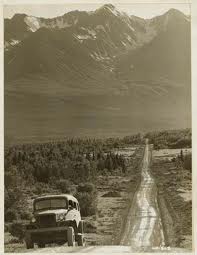
In 1942, the Army Corp of Engineers built the Alaska-Canadian Highway(service men called it the AlCan Highway) from Dawson Creek in the Yukon to Delta Junction, southeast of Fairbanks, Alaska. Initially, the rough gravel road was thought necessary for American national security during the Second World War.


Today, tourist travel the AlCan highway as a more adventurous route to Alaska than traveling by boat along the North American costal waterway.


Inside Passage

A highway to link the lower 48 states to Alaska Territory was first proposed in the 1920s by Donald MacDonald, a senior engineer with the Alaska Road Commission. MacDonald believed that a coastal route from Prince George in British Columbia to Alaska’s southeastern towns would benefit commerce and would be an easy route to forge over already familiar territory. The biggest problem in the 1920s for construction of the highway was convincing the Canadian government that a road through Canada was necessary; The Canadians were reluctant to provide funds reasoning that there were few Canadians living in the area proposed for the highway.

The attack on Pearl Harbor in 1941 and the fear of Japanese invasion of the North American coast and the Aleutian Islands brought the proposed highway back to the front burner. The United States Army believed that “a secure overland supply line to the unfinished airfields of the Northwest Staging Route and our military bases in Alaska was urgently needed.” The Army approved the project in 1942 and authorization from the U.S. Congress and President Franklin D. Roosevelt followed within days. Roosevelt understood that for homeland security there needed to be a supply line to airfields and military bases in Alaska. Roosevelt’s proposal was not without objections from those who considered many of the President’s programs “boon-doggles.” Roosevelt’s administration justified the billion dollar projected thusly: “That the effective defense of Alaska is of paramount importance to the defense of the continent from the west since Alaska is most exposed to an attempt by the enemy to establish a foothold in North American….That sea communications with Alaska in the future may be subject to serious interruption by enemy sea or air action. That the air route to Alaska and the defense facilities in Alaska cannot be fully utilized without adequate means of supply, for the air route, this can be best provided by a highway along this route.”

The need was apparent, the route was still contested. In all there were four routes considered; route A along the coast; route B following the Rocky Mountain Trench; route C inland; and route D, which followed the Mackenzie River System. Of all routes, the route C was the most difficult to cut and critics believed it would take the longest to forge through uncharted wilderness. But, the Army liked route C because it was a direct line to the newly constructed air bases.

The United States brokered a deal with Canada that allowed a highway through Canadian wilderness.


AlCan Highway 1942


Even though the Canadian Government had no objections to the route through Canada, they would not grant funds for the highway, and insisted that after the war the road would be turned over to Canada. The Army Corps of Engineers started work on the highway in late spring of 1942. It was not an easy engineering feat for the Army to construct a highway through 1522 miles of rugged unmapped wilderness.


Some compared the construction of the highway with the building of the Panama Canal and Hoover Dam. It was especially difficult to build the road considering that Army manpower for such projects was scarce. But, there was an untapped pool of men in the army’s black Corps of Engineers; The Army sent the 93rd, 95th , 97th and 388th units, trained in Alabama, Florida and Georgia, to help construct the highway. Of the 10,670 men, military and civilian who worked on the highway, 3, 695 of Army Troops were African-American.


At the beginning of armed conflict in Europe and the Pacific, African Americans in the U.S. Military were not allowed to serve on active duty. But, after the Japanese bombed Pearl Harbor, a lack of manpower in the army started to change the prevailing view of African American’s role in the United States armed forces. But, perhaps the attack by the Japanese at Midway Island, and the attack at Dutch Harbor in June 1942 in Alaska’s Aleutians Islands (the only battle in the Pacific War that was fought in North America ) brought home the necessity for all Americans to work along side one another for a common goal to defeat the enemy.

It took 8 months to build the Alaska-Canadian Highway. Construction began in the late Spring of 1942. The work was difficult if for no other reason than the wilderness terrain and the adverse weather condition. Memories of African-Americans mentioned the harsh living conditions in the very cold winter. They had to fight against frostbite and hoped to survive wading chest deep in freezing cold lakes to build bridges.


95th

During the winter months, the temperature dropped to -70 degrees. One veteran remembered. “ For months on end, I couldn’t get a real night’s sleep. I had nightmares I was freezing to death.”


"We wore three pairs of socks at times, with rubber galoshes instead of shoes, because the leather would freeze. We had adequate clothing-- lined parkas, pants, mittens and heavy underwear, but it was still might cold. But I was a young man who felt he had a job to do, and I did it."
-Alexander Powel, Crane Operator, 97th Engineers


The troops lived in temporary tent camps in an environment where temps could easily go to 40 below zero. Their mess facilities were out of doors and food was served up in mess kits that some suggested were “slightly improved from the Civil War.”


Their tents were equipped with wood stoves, wood they cut by hand with cross cut saws and double-bitted axes. These same axes were used to clear the highway path while bulldozers pushed stumps out of the way. Timber that they cleared was also used to make bridges and culverts.

The Alaska Canadian Highway took eight months to complete. Proponents of the highways believed it was the single most engineering feat of World War Two. The highway was immediately used as the intended supply line to air bases in Nome and Fairbanks. In all, 7000 planes were delivered to Alaska. All along the route, every 300 miles, the service men built gravel run ways for planes to refuel and continue their trek to Russia and the European Allies.

Building of the AlCan highway was more than an engineering feat; it brought together black and white soldiers who worked outside segregation for a common goal of duty and the protection of the United States of America.

The Army completed the AlCan Highway on November 20, 1942. Construction crews worked from both ends of the Highway and met at what is now called "Soldier's Summit" at Kluane Lake in Yukon Territory.


Kluane Lake
Henry George Glyde
Canadian (1906-1998)
Kluane Lake on Alaska Highway, 1949
oil on canvas
Glenbow Museum Collection

In 1948, the Alaska-Canadian Highway was opened to the public. The rough gravel road was paved in the 1990s


Today’s Highway